
Tropical disturbance expected to evolve into a tropical
cyclone by the weekend.

An area of disturbed weather in the central Gulf of Mexico continues to be watched very
closely. As of late Thursday morning, the National Hurricane Center places a 70% chance for
growth into a tropical depression or tropical storm in the next 48 hours, although no identifiable
low pressure area has been noted at the surface.
Emergency Manager Severe Weather Briefing Sept. 1, 2011---Page 2
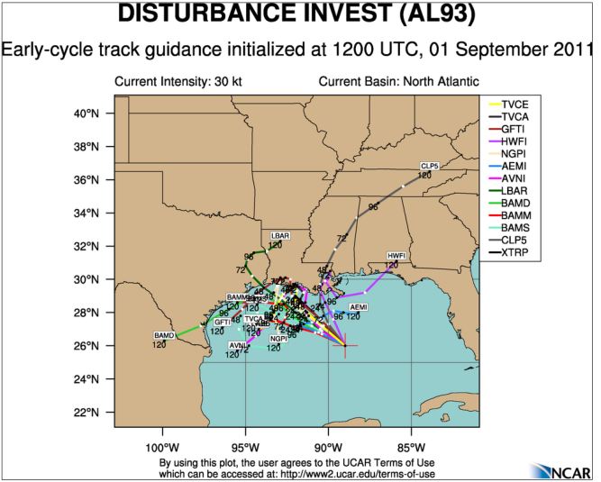
Once a center of low pressure is indentified, the system would likely be upgraded, as winds
aloft become more favorable for growth. Most of the forecast models for the past couple of
days develop this area into a tropical storm. The majority of the guidance moves the system
slowly northwest towards the Louisiana coast, where it then stalls. There is a large amount of
uncertainty in all aspects of this impulse, especially since no center has been identified, which is
important for the forecast models. The various forecast tracks are shown below as of early
Thursday morning.
Emergency Manager Severe Weather Briefing Sept. 1, 2011---Page 3
Key Points for this event:
Possible Tropical Storm evolution in the Gulf of Mexico over the next day or two.
Uncertainty is much higher than normal, especially since no organized center has
been identified.
At this time, system is expected grow into a Tropical Depression or Tropical Storm
as it meanders northwest towards Louisiana over the next two days.
Impacts, if any, should be confined along the Panhandle coast and western inland
counties into southeast Alabama where showers and thunderstorms could increase
as the system grows.
Beach goers in the Florida Panhandle over the holiday weekend will likely see high
surf and could see beach closures due to the rip current and high surf threats.
Minimal impacts over Georgia and Florida Bend counties are expected at this time
through Saturday, although clouds and showers may increase.
Evolution and track of this impulse too uncertain to give any definitive statements
regarding impacts late in the holiday weekend and into early next week.
All should keep a close eye on this impulse and monitor the latest guidance from
the NHC.
The National Weather Service in Tallahassee will continue to monitor this system closely. If
you have any questions, please give our office a call at 850-942-883,3 or on our toll free line at
800-598-4562, and ask to speak to a meteorologist. We are available 24 hours a day, 7 days a
week. You can also reach us on our Southern Linc phone at 1*77*184.
No comments:
Post a Comment